Gemeindelexikon der
im
Reichsrate vertretenen Königreiche und Länder.
|
| German | Ukrainian | Polish |
| Lemberg | L’viv | Lwów |
| Stanislau | Stanislaviv | Stanisławów |
A Ukrainian researcher should learn the Polish spelling of his/her village. Of course, there is often a similarity between the two languages that if the county (povit/powiat) is known, the locality should be readily recognizable.
Abbreviations
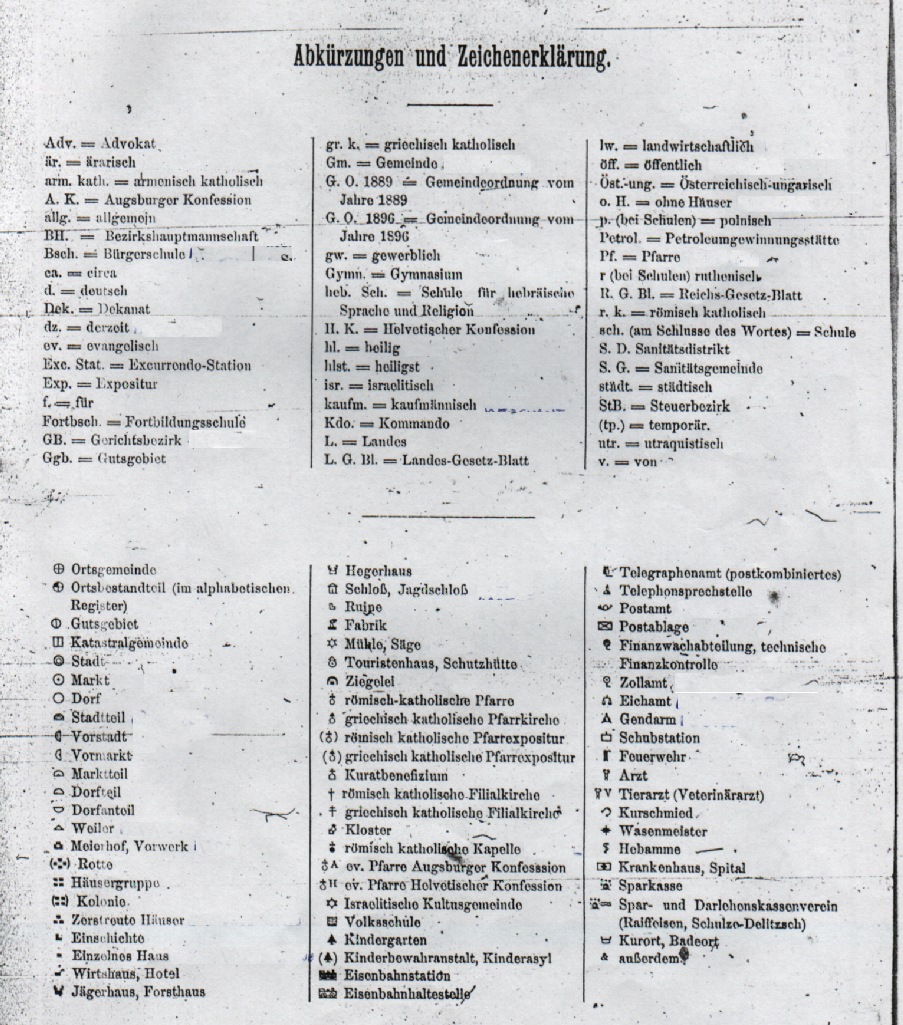
At the front of the gazetteer is a list of abbreviations and graphics with their corresponding meaning. These graphics are found throughout the gazetteer. They graphics, although often overlooked, provide a great wealth of detail about the town/village. They represent castle ruins, factories, mills, police stations, post offices, etc.
Click on the picture at left to open up a larger view.
The First Section
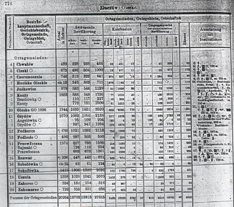
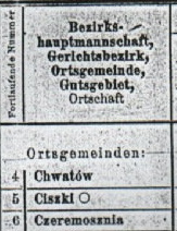
The first section is sorted alphabetically by administrative district (Bezirkshauptmannschaft, abbreviated BH in the gazetteer), then within each district by Judicial District (Gerichtsbezirk, abbreviated GB in the gazetteer). Within each judicial district is an alphabetical list of communities.
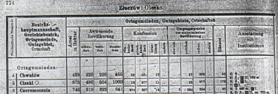
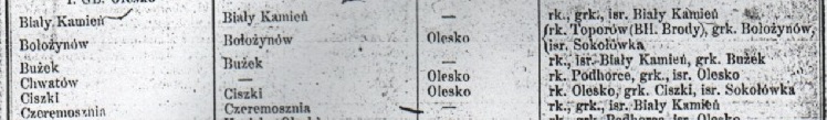
A community (gmina in Polish, hromada in Ukrainian) can consist of one village, or of several villages and/or hamlets, etc. If the community has multiple villages/hamlets, you'll find the names listed at the end of the list of communities. In the first example below, the community of Chwatów consists of the village of Chwatów and Trebaczówka. (You know that these two places are villages because of the symbol of the open circle. (The list of graphics above should be consulted for the various types of places.)
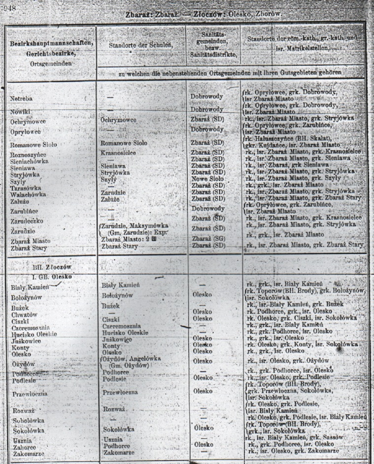
The second example is for #6, the community of Czeremosznia, which consists of the village of Czeremosznia, the group of houses called Lipina, and the hamlet of W Gaju.
![]()
The numbers following each place is for the number of houses and the population. In our example of the community of Czeremosznia, you'll find:
| Community parts | No. of houses | Population |
| Czeremosznia (village) | 85 | 585 |
| Lipina (group of houses) | 2 | 23 |
| W Gaju (hamlet) | 5 | 33 |
| Total | 95 | 641 |
(On a personal note, my grandfather always told me that his father was born in "v hayu/w gaju". No matter how hard I searched, I could never find anything about this place. This gazetteer is the only one of its kind to list that such a place called "v hayu/w gaju" existed as a hamlet found as part of the village Cheremoshnya/Czeremosznia.
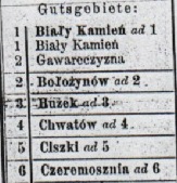
An often misunderstood part of the gazetteer is the two listings of communities: one into (Ortsgemeinden) and the other into manor house/grounds (Gutsgebiete). The distinction was important in the times of the Austro-Hungarian Empire. Remember that the population of the manor house/grounds was not confined to the family of the house, but extended to servants and workers living on the estate.
There is a summary of statistics after each judicial district and administrative district. In German, it is called "Rekapitulation".
The columns of statistics for each locality (for both the village proper and the manor house) are as follows:
| Areal in Hektar | Area in hectors |
| Anwesende Bevolkerung | Present population |
| Mannlich | Male |
| Weiblich | Female |
| Zusammen | Total |
| Konfession | Religion |
| Rom.-katholisch | Roman Catholic |
| Griech-katholisch | Greek Catholic |
| Israelitisch | Jewish |
| Andere | Others |
| Umgangspreche der einheimischen Bevolkerung | Colloquial speech of the native population |
| Deutsch | German |
| Polnisch | Polish |
| Ruthenien | Ukrainian (often seen as Ruthenian in older texts) |
| Andere | Others |
| Hauser | Houses |
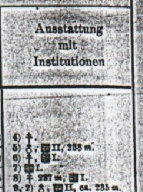
| Ausstattung mit Institutionen | Equipment with institutions |
| Viehstand | Livestock |
| Pferde | Horses |
| Rinder | Cattle |
| Schafe | Sheep |
| Schweine | Pigs |
| Bezirkshauptmannschaft | District center |
| Steuerbezirk | Tax district |
| Katastralgemeinde | Cadastral community |
| im ganzen | on the whole |
| Steuerphlichtige Flachen | Taxable surfaces |
| Acker | Fields |
| Wiesen | Meadows |
| Garten | Gardens |
| Hutw. und Alpen | Pastures (Hutweide) and "Hilly Pastures" <Thank you, David Gorz, member of the Galizien German Descendants!> |
| Wald | Forests |
| Anzahl der... | Number of... |
| Grossgrundbezitzungen | Greatlanded property |
| Fabriken | Factories |
I personally enjoy referring to such information, which can liven our own family history and allows one to envision life in the ancestral village at the turn of the last century. Of course, if you’re one to only concern yourself with researching names and dates of your own direct line, you may still find this information relevant. If, for instance, you think you’ll find all your ancestors in only the Roman Catholic parish registry, take a good look at the statistics for your village regarding religion. If you find your village has a great many Greek Catholics living in the same village, it will prove to you that intermarriage between Roman Catholics and Greek Catholics wasn’t only possible, but very probable. (Even with such information, one should always look in both Catholic rites’ parish registries.) Furthermore, one can see what other villages were in the same area to give you leads for finding and "missing" relatives from parishes you’ve been studying.
In addition to the obvious statistics, pay particular attention to all of the graphics and notes.
The graphics next to the locality name illustrates
whether it was considered a village, hamlet, etc.
A full circle means "village", a half circle means "hamlet", etc.
 |
Match the number to the LEFT of the village name to the number in the right hand column "Ausstattung mit Institutionen/ Equipment with institutions". This will give more information about the village/town, such as whether there was a Roman Catholic church, Greek Catholic church, school, etc. |
 |
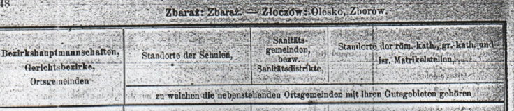
Second Section
The last half of the gazetteer lists again all of the villages and towns alphabetically, first by Administrative District, then by Judicial District, then by Locality
 .
.
The columns are:
| Standorte der Schulen | School district |
| Sanitatsgemeinden, bezw. Sanitatsdistrikte | Health municipality |
| Standorte der rom.-kath. (rk.) | Roman Catholic parish |
| Standorte der gr.-kath. (grk.) | Greek Catholic parish |
| und isr. Matrikelstellen (isr.) | Jewish congregation |
The most important feature here, of course, is the listing of the parish/congregation for each locality. This information is invaluable when looking for information on which parish you should check for vital records. Of course, the information is relative only to 1907. One should keep in mind that the parish boundaries may have changed over the years and that your ancestors may have moved to a neighboring parish. Brian Lenius’ work, The Genealogical Gazetteer of Galicia, which the author compiled from dozens of sources, will give more details as to various districts and parishes each particular locality may have belonged to.
Click on the picture at the right to see a larger view.
To view statistics from this gazetteer, view the pages below:
- Austria-Hungary: 1907 Statistics. Religion by county (all of Galicia)
- Austria-Hungary: 1907 Statistics. Language by county (all of Galicia)
|
www.halgal.com
Questions and Comments to Matthew
Bielawa |